Metes and Bounds
Definition and meaning of Metes and Bounds in real estate.
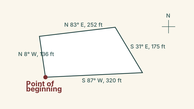
Metes and bounds is a traditional system of land description that outlines the boundaries of a parcel of property using physical features, distances, and angles.
In more detail
It starts at a specific point of beginning and traces the perimeter of the land until returning to the starting point. This surveying method is one of the oldest ways to define real estate boundaries in the United States, particularly in the eastern states. The term metes refers to measurements of distance, while bounds refers to boundaries such as roads, streams, trees, or neighboring properties.
Modern metes and bounds descriptions use precise GPS coordinates and angles, but they still follow the same circular path format. Title companies and attorneys rely on these descriptions to verify exactly what land is being transferred in a deed.
Key facts
| Category | Legal, Titles & Closing |
|---|---|
| Key requirement | Must always return to the original point of beginning to close the loop |
| Common elements | Uses angles, compass directions, distances, and physical monuments |
| Geographic prevalence | Common in the eastern US states and areas not covered by the public land survey system |
A legal deed describes a parcel of land as starting at the stone marker on the highway, running north for two hundred feet, turning east for one hundred fifty feet to a creek, following the creek south, and then returning to the stone marker.
Frequently asked questions
What happens if a metes and bounds description does not close?
If the description fails to return to the point of beginning, it is legally defective and must be corrected by a surveyor to avoid title disputes.
How does metes and bounds differ from the lot and block system?
Metes and bounds uses distances and boundaries to describe a shape, while lot and block references a numbered lot on a recorded subdivision map.
Related terms
Sources & references
See our sources and editorial standards.